Canada
🌎 Available Across Canada🔗
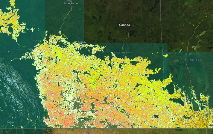
The EarthDaily Crop Identification product is fully operational across the growing regions of Canada, providing in-season crop classification for major crops. From Ontario to the Great Plains, it delivers timely, consistent, and high-resolution insights into crop distribution—supporting critical decisions in one of the world’s largest agricultural producers.
Coverage includes key crops such as Corn, Barley, Canola, Spring Wheat, Winter Wheat, Soybean and Hay/pasture.
Additional crops can be supported upon request or as part of our product roadmap.
📤 In-Season Deliveries🔗
Crop classification layers are delivered during the growing season, with progressive updates that incorporate the latest satellite imagery and weather-adjusted model outputs.
Delivery schedule:
- July 15th (in-season)
- September 30th (end of season)
Additional delivery dates can be added upon request. This cadence enables organizations to track acreage distribution and refine supply outlooks as the season advances.
🎯 Model Performance🔗
Our AI models deliver the following accuracy ranges by crop type and time of season, represented by an F1 score as follows. Below are results achieved after rigorous cross-validation evaluation over 6 years (2019-2025). In-season scores are the lower end of the range and end of season scores reflect higher accuracy.
- Corn: 0.78-0.88
- Barley: 0.38-0.54
- Canola: 0.77-0.84
- Spring Wheat: 0.67-0.72
- Winter Wheat: 0.70-0.73
- Soybean: 0.71-0.86
- Hay/pasture: 0.84-0.86
🗺️ Historical Layers🔗
To support long-term analysis, we provide historical crop classification layers starting from 2019 using public ACI datasets. All layers are referenced in one place for convenience, enabling seamless analysis of historical trends, crop rotations, and year-over-year changes — without the need to manage multiple data sources.
🔧 Flexible Delivery Options🔗
The product is designed for seamless integration into your workflows, with two API-based delivery mechanisms:
- EarthData Store API (STAC): Access spatially indexed, pre-processed crop maps in standard geospatial formats such as GeoTIFF—ideal for large-area analysis.
- Field-Level API: Retrieve crop type predictions linked to known field boundaries for precision use at the farm or parcel level.
Both options are scalable, reliable, and built to fit directly into your data pipeline.
Explore full technical specifications in our API Documentation.
❓ FAQ🔗
What crops are covered in EarthDaily’s Canada Crop Identification product?
Corn, Hay/pasture, Soybean, Spring Wheat, Winter Wheat, Barley, and Canola/Rapeseed.
How accurate is the model?
F1 scores range from 0.54 - 0.88, depending on crop and based on historical, in-season, and end of season performances.
How often is the data updated?
Twice per cropping season, with progressive refinement as more satellite imagery is collected.
Can I access data for past seasons?
Yes, historical data is available from 2019 onward.
What regions of Canada are supported?
Coverage spans the major growing regions of Ontario, Manitoba, Alberta, and Saskatchewan.
What if I only need data for specific areas?
You can request access to selected provinces or regions as needed.